Documents
This section features public documents and files uploaded by the stakeholders and custodians of the Caspian Sea environment.
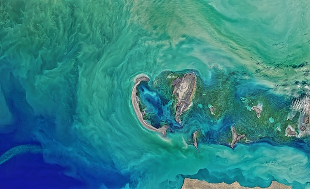
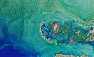
 Колебания уровня каспийского моря и диагностика современных изменений положения береговой линии по спутниковым данным Landsat периода 2005…2015 годовThu, 09/08/2018 - 13:45Рассмотрены вопросы, связанные с проблемой колебаний уровня Каспийского моря и их влияний на прибрежную зону казах-станского сектора. По данным картирования спутниковых снимков площадь осушения в северо-восточной части Каспийского моря в период между 2005 и 2015 гг. составила 5055 км2. В некоторых районах море отступило на 2
- Description
Рассмотрены вопросы, связанные с проблемой колебаний уровня Каспийского моря и их влияний на прибрежную зону казах-станского сектора. По данным картирования спутниковых снимков площадь осушения в северо-восточной части Каспийского моря в период между 2005 и 2015 гг. составила 5055 км2. В некоторых районах море отступило на 25 км
- Attached documents
- Metadata
- Year
- 2015
 Article - Long-term and seasonal Caspian Sea level change from satellite gravity and altimeter measurementsMon, 16/07/2018 - 15:43The article examines recent Caspian Sea level change by using both satellite radar altimetry and satellite gravity data. The altimetry record for 2002–2015 shows a declining level at a rate that is approximately 20 times greater than the rate of global sea level rise. Seasonal fluctuations are also much larger than in the wo
- Description
The article examines recent Caspian Sea level change by using both satellite radar altimetry and satellite gravity data. The altimetry record for 2002–2015 shows a declining level at a rate that is approximately 20 times greater than the rate of global sea level rise. Seasonal fluctuations are also much larger than in the world oceans. With a clearly defined geographic region and dominant signal magnitude, variations in the sea level and associated mass changes provide an excellent way to compare various approaches for processing satellite gravity data.
- Attached documents
- Metadata
- Year
- 2017
 Article - Impact of the Alien Species Mnemiopsis leidyi A. Agassiz, 1865 on Fish of the Caspian SeaMon, 16/07/2018 - 15:13The data of long-term ecological studies (1999–2014) are used for assessing the impact of a new Caspian invader Mnemiopsis leidyi A. Agassiz, 1865 on marine and anadromous fish species. The introduction of the ctenophore and its massive development in the Caspian Sea have mainly affected planktophagous fish, especially the m
- Description
The data of long-term ecological studies (1999–2014) are used for assessing the impact of a new Caspian invader Mnemiopsis leidyi A. Agassiz, 1865 on marine and anadromous fish species. The introduction of the ctenophore and its massive development in the Caspian Sea have mainly affected planktophagous fish, especially the most abundant species anchovy sprat (Clupeonella engrauliformis Borodin, 1904) and sturgeons (Family Acipenseridae). Mnemiopsis leidyi is one of the main negative factors preventing the restoration of the populations of Caspian fishes, especially anchovy tyulka. The critical state of the resources of the spawning parts of sturgeon populations (Family Acipenseridae) has been reinforced as a result of the massive development of M. leidyi.
- Attached documents
- Metadata
- Year
- 2018
 Average Precipitation & Evaporation in the Caspian Sea 2000-2015Tue, 12/06/2018 - 10:53Average precipitation and evaporation in the Caspian Sea in 2000-2015. Created by Manana Kurtabadze.
- Description
Average precipitation and evaporation in the Caspian Sea in 2000-2015.
Created by Manana Kurtabadze.
- Attached documents
- Metadata
- Year
- 2018
 Article - Effects of Caspian Sea water level fluctuations on existing drainsMon, 23/04/2018 - 19:18This study is an attempt to develop an integrated methodology to predict the impact of the Caspian Sea on flooding using Geographic Information Systems (GIS) and hydrodynamic modeling. A rise in the sea level might lead to major flooding events, and have a severe impact on the spatial development of cities and regions. The f
- Description
This study is an attempt to develop an integrated methodology to predict the impact of the Caspian Sea on flooding using Geographic Information Systems (GIS) and hydrodynamic modeling. A rise in the sea level might lead to major flooding events, and have a severe impact on the spatial development of cities and regions. The feasibility of simulating a flood event along a drain channel is evaluated near residential development areas along the Chapakroud drain.
The study shows that at these elevations environmental and social problems arise with regards to the drain. The results also indicate that GIS is an effective tool for floodplain visualization and analysis. It should be noted that the mixture of salt and soft water, as a result of rising sea water level, is a problem that was not investigated in this study and should be examined in the future.
- Attached documents
- Metadata
- Year
- 2011
 Article - Review of the status of invasive species, with special focus on the most invasive species Mnemiopsis leidyi A.Agassiz, 1865 and their effects on the Caspian ecosystemSun, 22/04/2018 - 16:13The main focus of review: To determine the Status of invasive species with special attention to the most aggressive invader Mnemiopsis leidyi in the Caspian Sea. Objectives: 1. To assess vectors, pathways of invasive species introduction, their composition and their role in the Caspian ecosystem. 2. To analyze seasonal an
- Description
The main focus of review: To determine the Status of invasive species with special attention to the most aggressive invader Mnemiopsis leidyi in the Caspian Sea.
Objectives:
1. To assess vectors, pathways of invasive species introduction, their composition and their role in the Caspian ecosystem.
2. To analyze seasonal and interannual dynamics of the Mnemiopsis leidyi population in the all areas of the Caspian Sea; its impacts on the Caspian ecosystem including food recourses (zooplankton) and fish stocks along with other emerging environmental threats such as increased nutrient load from the coast, structural and quantitative changes in phyto-and-zooplankton communities, the appearance of harmful algal bloom (HAB) in the Southern Caspian.
3. To prepare recommendations for follow-up actions on invasive species management: - for the protection and control of the Caspian Sea from any sources of accidental invasive species introductions - for possibility of biological control of invader Mnemiopsis leidyi.
The primary source of this Review has been national reports from every of the five Caspian littoral countries, which included results of national observations of ecosystem state and biodiversity of the Caspian Sea. But due to fragmental data of the national observations on invasive species
- Attached documents
- Metadata
- Year
- 2011
Document
Колебания уровня каспийского моря и диагностика современных изменений положения береговой линии по спутниковым данным Landsat периода 2005…2015 годов
Document

Article - Long-term and seasonal Caspian Sea level change from satellite gravity and altimeter measurements
Document

Article - Impact of the Alien Species Mnemiopsis leidyi A. Agassiz, 1865 on Fish of the Caspian Sea
Document
Average Precipitation & Evaporation in the Caspian Sea 2000-2015
Document
Article - Effects of Caspian Sea water level fluctuations on existing drains
Document