Documents
This section features public documents and files uploaded by the stakeholders and custodians of the Caspian Sea environment.
 Информационный бюллетень о состоянии окружающей среды Республики КазахстанSun, 08/07/2018 - 19:49Информирование о состоянии окружающей среды на территории Республики Казахстан и оценка эффективности мероприятий в области охраны окружающей среды
- Description
Информирование о состоянии окружающей среды на территории Республики Казахстан и оценка эффективности мероприятий в области охраны окружающей среды
- Metadata
- Year
- 2015
- Информационный бюллетень о состоянии окружающей среды Республики КазахстанSun, 08/07/2018 - 19:44Информирование о состоянии окружающей среды на территории Республики Казахстан и оценка эффективности мероприятий в области охраны окружающей среды
- Description
Информирование о состоянии окружающей среды на территории Республики Казахстан и оценка эффективности мероприятий в области охраны окружающей среды
- Metadata
- Year
- 2015
- Информационный бюллетень о состоянии окружающей среды Республики КазахстанSun, 08/07/2018 - 19:40Информирование о состоянии окружающей среды на территории Республики Казахстан и оценка эффективности мероприятий в области охраны окружающей среды
- Description
Информирование о состоянии окружающей среды на территории Республики Казахстан и оценка эффективности мероприятий в области охраны окружающей среды
- Metadata
- Year
- 2015
- Информационный бюллетень о состоянии окружающей среды Республики КазахстанSun, 08/07/2018 - 19:21Информирование о состоянии окружающей среды на территории Республики Казахстан и оценка эффективности мероприятий в области охраны окружающей среды
- Description
Информирование о состоянии окружающей среды на территории Республики Казахстан и оценка эффективности мероприятий в области охраны окружающей среды
- Metadata
- Year
- 2012
 The Legal Status of the Caspian SeaMon, 23/04/2018 - 19:33The presented book represents an attempt to identify comprehensive solution to the problem of the international legal status of the Caspian Sea. The unclear legal situation of the Caspian Sea and the consequent uncertainty of the coastal states about the issue of territorial demarcation, their uncertainty about the extent of
- Description
The presented book represents an attempt to identify comprehensive solution to the problem of the international legal status of the Caspian Sea. The unclear legal situation of the Caspian Sea and the consequent uncertainty of the coastal states about the issue of territorial demarcation, their uncertainty about the extent of their sovereign rights to the exploitation of natural resources and the uncertainty of the neighboring states with regard to shipping in the Caspian prevent continuous economic development of the region, destabilize political situation and result in a lack of security in the Caspian region. These issues are not merely of regional, but of a global importance. This is the way the research is being continued by scientist all over the world.
- Attached documents
- Metadata
- Year
- 2015
 Recent Oil Spill Preparedness Developments in the Caspian Sea RegionMon, 23/04/2018 - 19:12Natural seeps and easily exploited surface deposits of crude oil on land have been utilized in the Caspian Sea region earlier than 300 BC. The modern-day picture is a region with oil reserves of global importance, facing a key challenge of the transportation of crude oil to markets. There has been considerable focus on devel
- Description
Natural seeps and easily exploited surface deposits of crude oil on land have been utilized in the Caspian Sea region earlier than 300 BC. The modern-day picture is a region with oil reserves of global importance, facing a key challenge of the transportation of crude oil to markets. There has been considerable focus on developing oil spill preparedness in the Caspian Sea region. This has involved the governments, regional bodies, the oil industry and a range of other stakeholders and international organizations (notably UNEP, IMO and OSCE). This effort is in addition to the primary focus on preventing spills.
Countries are developing and implementing National Contingency Plans in order to have effective national response systems, which also act as the basis for regional cooperation.
- Attached documents
- Metadata
- Year
- 2015
 Biodiversity of the North East Caspian regionMon, 23/04/2018 - 18:44This brochure has been produced on behalf of the consortium developing the hydrocarbon deposits beneath the North East Caspian defined under the North Caspian Sea Production Sharing Agreement of 1997. The concession area lies in a region of rich biodiversity recognized as being of international importance for its wildlife,
- Description
This brochure has been produced on behalf of the consortium developing the hydrocarbon deposits beneath the North East Caspian defined under the North Caspian Sea Production Sharing Agreement of 1997.
The concession area lies in a region of rich biodiversity recognized as being of international importance for its wildlife, including several species that are classified as endangered. The widely varying conditions in the North East Caspian include extreme seasonal temperature variations, long-term sea level change, short-term sea surges and retreats, high levels of turbidity and sediment movement, ice cover in winter and scouring of the seabed by moving ice.
This dynamic environment presents challenges for those who live and work in the area. It also means that the fauna and flora on land and at sea, are adapted to a significant level of environmental stress from continually changing physical conditions.
- Attached documents
- Metadata
- Year
- 2015
 Concept of creating the Atlas of the Caspian Sea and its coasts - Presentation by Prof. MammadovMon, 23/04/2018 - 17:52Presentation by Professor Ramiz M. Mammadov (Institute of Geography, NANA). The Institute of Geography of the Azerbaijan National Academy of Sciences and the Institute of Geography of the Russian Academy of Sciences have the honour to propose the development of the Atlas of the Caspian Sea (electronic and paper version), w
- Description
Presentation by Professor Ramiz M. Mammadov (Institute of Geography, NANA).
The Institute of Geography of the Azerbaijan National Academy of Sciences and the Institute of Geography of the Russian Academy of Sciences have the honour to propose the development of the Atlas of the Caspian Sea (electronic and paper version), which aims to be a product of international scientific collaboration among the five Caspian states. The Atlas should serve the purpose of collecting and maintaining a comprehensive data on the state of the environment of the Caspian Sea and lay the scientific foundation for the environmental monitoring programme and implementation of other provisions of the Convention and its Protocols.
- Attached documents
- Metadata
- Year
- 2015
 National Convention Action Plan NCAP 2012Sun, 22/04/2018 - 20:06National Convention Action Plan NCAP of the five Parties - Year 2012+9
- Description
National Convention Action Plan NCAP of the five Parties - Year 2012
- Attached documents
- Metadata
- Year
- 2012
 Celebration of Caspian Day in Turkmenistan: Final ReportSun, 22/04/2018 - 07:45Objectives of the project included the organization and performance of the coast-wide awareness campaign in Turkmenbashi and Awaza area devoted to the Caspian Sea Day celebration. The project was prepared and agreed with the program of Celebration with the Ministry of Nature Protection of Turkmenistan, which supposed to be h
- Description
Objectives of the project included the organization and performance of the coast-wide awareness campaign in Turkmenbashi and Awaza area devoted to the Caspian Sea Day celebration. The project was prepared and agreed with the program of Celebration with the Ministry of Nature Protection of Turkmenistan, which supposed to be held in hotel “Dayanch” on the Caspian coast. The events were planned for August 10-11, 2012. However due to force-major reasons, upon arrival of participants of the event to Turkmenbashy city, the organizers were asked to postpone the event. It was decided to perform it in Ashgabat at the premises of the Institute of Deserts. Due to the summer beach time, it was impossible to change tickets and go back to Ashgabat earlier. Thus the Caspian Day event was then again prepared and performed in Ashgabat.
- Attached documents
- Metadata
- Year
- 2012
 Akzhaiyk Reserve General InformationSat, 21/04/2018 - 11:16State Nature Reserve "Akzhaiyk" (Kazakh "Aқzhayyқ" memlekettіk tabiғi reserves) is located in the Makhambet Atyrau region, in the surrounding lands outside the city of Atyrau. It was created by the Government of the Republic of Kazakhstan on February 6, 2009 in the delta of the Ural River and the adjacent coast of the Caspia
- Description
State Nature Reserve "Akzhaiyk" (Kazakh "Aқzhayyқ" memlekettіk tabiғi reserves) is located in the Makhambet Atyrau region, in the surrounding lands outside the city of Atyrau. It was created by the Government of the Republic of Kazakhstan on February 6, 2009 in the delta of the Ural River and the adjacent coast of the Caspian Sea. [1] The Ural River Delta and the adjacent coast of the Caspian Sea is included in the list of wetlands of international importance. The reserve was the second Kazakh territory after the Tengiz-Korgalzhyn lake system, which went down in the list. The hydrological regime is characterized by a gradual rise the water level in the Ural River in the second half of April, with the transition in May-June in spring and summer, with a peak at the end of May or the first half of of June. After the first flood peak starts fast and then gradual decline, passing in August and September in the autumn low water.
- Attached documents
- Metadata
- Year
- 2012
- Statistical Yearbook of Azerbaijan 2015Fri, 20/04/2018 - 15:25Being an annual official statistical issue reflecting processes occurred in social, economic, demographic and ecological life of the country the yearbook is prepared based on data of statistical report forms, censuses, sample surveys and other statistical observation forms received by statistical bodies from enterprises, org
- Description
Being an annual official statistical issue reflecting processes occurred in social, economic, demographic and ecological life of the country the yearbook is prepared based on data of statistical report forms, censuses, sample surveys and other statistical observation forms received by statistical bodies from enterprises, organizations, households and natural entities as well as from ministries, committees, departments and international organizations.
The Statistical Yearbook reflecting social-economic indicators of 2014 in comparison with indicators of 2005-2013 will meet data requirements of widerange of readers and other users.
- Attached documents
- Metadata
- Year
- 2015
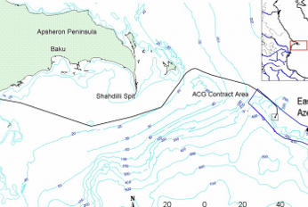
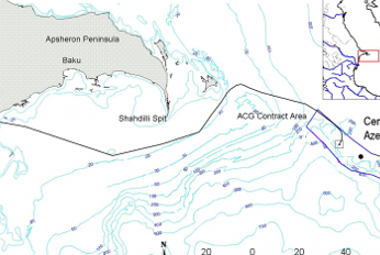 Central Azeri Environmental Survey July 2010 AmC Project 10502Tue, 17/04/2018 - 15:02Sampling was conducted from the vessel Svetlomor 2 by personnel from AmC, the Ministry of Ecology and Natural Resources (MENR) and SOCAR. Sediment samples for physical and chemical analysis consisted of 2 replicates, while 3 replicates were taken for biological analyses. Analyses were carried out at AmC Caspian Environmental+5
- Description
Sampling was conducted from the vessel Svetlomor 2 by personnel from AmC, the Ministry of Ecology and Natural Resources (MENR) and SOCAR. Sediment samples for physical and chemical analysis consisted of 2 replicates, while 3 replicates were taken for biological analyses. Analyses were carried out at AmC Caspian Environmental Laboratory.
Sediments around Central Azeri were very poorly sorted, the majority being a mixture of sand and gravel. At many stations, the two replicates were substantially different, indicating patchiness of physical characteristics on a small spatial scale (metres).
LAO was detected at 7 stations in 2010. There was little evidence of change at the majority of stations, and the overall area within which LAO was observed remains very similar to that observed in previous surveys. In general the hydrocarbon concentrations were low or very low and UCM and NPD content were indicative of weathered material being present throughout the survey area.
For the majority of trace metals the data show no clear trends or gradients which could be associated with platform activities. Three elements – barium, cadmium, and lead – exhibited very similar concentration patterns. These were the only elements which indicated a ‘footprint’ which was spatially related to the platform location. A similar association was evident in the 2008 data.
The macrobenthic community was numerically dominated by amphipods which were also the most taxonomically rich group. There was a general tendency towards lower species richness and abundance at stations to the north of, and immediately to the south of, the platform, as was also noted in 2008.
The 2010 data for sediment composition, chemistry and macrobenthic biology suggest that there is an area immediately around the platform in which some degree of sediment alteration is present, and where there is a slightly lower macrobenthic community biomass and diversity relative to more distant stations. However, there are no stations which could be considered biologically impoverished compared to previous surveys.
- Attached documents
- Metadata
- Year
- 2012
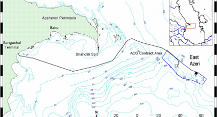
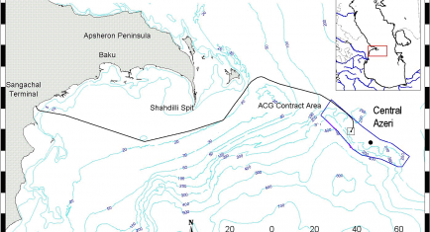
 East Azeri Environmental Survey July/August 2010 AmC Project 10503Mon, 16/04/2018 - 16:17Technical Summary Sampling was conducted from the vessel Svetlomor 2 by personnel from AmC, the Ministry of Ecology and Natural Resources (MENR) and SOCAR. Sediment samples for physical and chemical analysis consisted of 2 replicates, while 3 replicates were taken for biological analyses. Analyses were carried out at AmC Ca+5
- Description
Technical Summary
Sampling was conducted from the vessel Svetlomor 2 by personnel from AmC, the Ministry of Ecology and Natural Resources (MENR) and SOCAR. Sediment samples for physical and chemical analysis consisted of 2 replicates, while 3 replicates were taken for biological analyses. Analyses were carried out at AmC Caspian Environmental Laboratory.
The sediments around East Azeri were very poorly sorted with generally good agreement between replicate samples.Variation between metal concentrations was low.
Metal and hydrocarbon concentrations were, with the exception of Ba and Cd, within the range of baseline conditions for the ACG contract area, and in many instances were lower in 2010 than in 2008.
The condition of the macrobenthic community throughout the survey area was, in 2010, better than in 2008, and was closer to the original baseline conditions. There was no evidence that any physical or chemical parameter was associated with impaired community structure or function, although it was clear that the dominant taxonomic groups were more diverse and abundant in coarser sediments.
Specifically, the results of the 2010 survey show no evidence of sustained impact as a result of continuing platform drilling and production operations; there has (with the possible exception of Cd) been no evidence of direct contamination, and the diversity, abundance and biomass of the macrobenthic community has improved since 2008.
- Attached documents
- Metadata
- Year
- 2012
Document
Информационный бюллетень о состоянии окружающей среды Республики Казахстан
Document
Информационный бюллетень о состоянии окружающей среды Республики Казахстан
Document
Информационный бюллетень о состоянии окружающей среды Республики Казахстан
Document
Информационный бюллетень о состоянии окружающей среды Республики Казахстан
Document

The Legal Status of the Caspian Sea
Document

Recent Oil Spill Preparedness Developments in the Caspian Sea Region
Document

Biodiversity of the North East Caspian region
Document
Concept of creating the Atlas of the Caspian Sea and its coasts - Presentation by Prof. Mammadov
Document

National Convention Action Plan NCAP 2012
Document

Celebration of Caspian Day in Turkmenistan: Final Report
Document
Akzhaiyk Reserve General Information
Document
Statistical Yearbook of Azerbaijan 2015
Document
Central Azeri Environmental Survey July 2010 AmC Project 10502
Document